Friday, November 30, 2007

Don't High-Fire Andrill Penguins!

Penguin made in mold from ordinary slip clay (?)
that has been glazed and is awaiting firing
The title of this blog requires some explanation. Do you recall that several weeks ago I mentioned going to the ceramics room sometimes? What I did was I took the fine material that accumulated in the boxes beneath the rock saws that we were using to cut samples from the core for various research purposes.
Rock Trimsaw used for cutting
samples for research from Andrill Core
Bucket of 'cuttings' collected
from box beneath rock trimsaw
I had the vision of making a world-class piece of art from Andrill clay. Note that the last time I touched clay was in Middle School or High School. Luckily I was able to turn to some of the regulars in the ceramics room for help, which include John, Denise, Jena, and Dave, as well as Brie and Meredith.
John working on an intricate pattern on a vase.
John is a master of patience and a ceramics room guru.

First of all, the material I had from the saw included lots of silt and coarser particles, so I had to wet it, make it really goopy, and put it through a sieve. John suggested that I try a mold.

The goopy mud mixture I used in my efforts to make a penguin mold

Penguin #1
They have a neat penguin mold. Basically one just pours the goopy clay in, then pours it out again, and repeats several times, then leave it for 24 to 48 hours to dry somewhat, then take it out, let it dry a bit more, then sand any irregularities off, and it is ready for ‘bisque-firing’ or ‘low firing’ in the kiln. This was all really exciting, and I got lots of help from people – they were all quite curious to see whether it would work.

Denise works on trimming one of her works of art
So far so good. It came out of the kiln after bisque firing a deep reddish-brown color. I did not think to take any pictures of my prized Andrill penguin. I then decided I would just clear glaze it – I thought that the natural purity of 13 million-year-old McMurdo Sound clay and silt in my artwork should be allowed to shine through.

Gena working on adding handles to some cups. She is a cup-making demon.
She works as a Helo-Tech (the person who helps people buckle themselves safely
into a helicopter, and makes sure the cargo is loaded safely,
and rides with the pilot and helps in landings and take-offs).

Several days later I went in to the ceramics room and Gena looked at me with downcast eyes “I have some sad news for you.” My penguin had collapsed and turned in to a glazed mass of pottery –but it was a beautiful deep green color.

Remains of penguin #1

Moral of the story: One cannot ‘high fire’ Andrill penguins because the material does not have enough clay in it to bind it –it is too silty, and it just 'flows'. The experts in the ceramics room all reckon that I will be able to low-fire Andrill creations without them collapsing, because the low fire is the same temperature as the bisque-firing, which we know worked. We have yet to see …

Penguin # 2
I tried pouring the goopy mixture into the mold again, but I didn’t trim it properly at the top, so it cracked as it dried. I then needed to ‘rehydrate’ the clay and add some ordinary clay to help bind the siltier material together.

Penguin # 3
I poured the goopy mixture into the mold again, and left it to dry – carefully making sure that I trimmed the material at the top. That was Sunday. Monday I went to Cape Evans (and saw REAL penguins), then I was working Tuesday, Wednesday and Thursday evenings. Whoops. I went in tonight, and the penguin was cracked – I had left it in the mold too long.

Ceramic penguin rookery - the creations of Dave - who helped me save Trivet # 2
Dave hand sculpts marine mammals. He is currently working on a fish for one of the biologists.

Penguin # 4
I poured it into the mold tonight (Friday 30th), and I am hoping that everything works. I will have to make sure that I get back to the ceramics room sometime before Sunday night.

Trivet # 1
I have also tried making several trivets. Basically I added ordinary clay to the Andrill clay and I let it dry out a bit, then I rolled it out, and let it dry a bit more until I could carve the texture for my picture into the clay. The first one is a map of Antarctica showing the winter and summer sea-ice extent. It has just been bisque-fired, but is not out of the kiln yet. It definitely won’t make it into a museum – it was quite buckled and upturned at the edges before going in to the kiln – but I am hoping it stays in one piece, so I can glaze it.

Trivet # 2
I used the same process as for Trivet # 1, except I scored it more (too) deeply to prevent it from curling or buckling. I carved a scence from Beacon Valley into it. Then I lifted it up, and it broke along the score lines. Luckily Dave and John were there, and Dave helped me patch it with paper clay. Today I tried to tidy up the carved surface, and put it on the shelf for bisque firing.

I’ll miss the ceramics room – playing around and being creative is something I do not normally get the time to do, and I have really enjoyed going there when I have the time. I have also gotten to meet and talk with people at McMurdo that are not part of Andrill, which is good.

Brie (she is a baker in the kitchen) and
Meredith (works in the kitchen) work on their creations

So, even if Penguin #4 bites the dust, I’ll still be happy about all the time I spent over there – thanks y’all. I've accepted the reality that I will not create a museum centerpiece - I just hope that something I make stays together so I can take it home!

Launching a Met Balloon

November 17, 2007


Meteorological (met) balloons are launched from McMurdo twice daily to gather atmospheric data that helps predict the weather. A weatherman’s job in Antarctica is especially difficult for several reasons. First, there is no radar data for the meteorologists to use for this area. Think about how our weathermen at home use radar images as a matter of course! Second, weather here can change dramatically and dangerously in just a matter of hours. But the greatest challenge for the weather predictors here is that they are acutely aware that people’s lives depend on the accuracy of their predictions. Helicopter flights and fixed wing flights are governed by the decisions made at the Met Center, as are field teams’ travel plans. If a plane takes off, it must be able to fly to its destination. There are precious few other places for them to land if the weather deteriorates.

So, imagine my excitement when Patricia Ballou invited me to launch one of the met balloons. Patricia has quite an amazing story. She is on a leave from the army where she has deployed to the Mideast twice, once to Iraq and once to Afghanistan. She worked as a combat weatherperson in the army and is now gathering data and helping predict the weather in Antarctica this year. She is also writing climate interviews for Celsias. Check out her interview with David Harwood, the co-chief of ANDRILL and keep watching for an interview she is working on with me! (www.celsias.com then scroll down the right side to Patricia’s name.)


Patricia is adding in weather data to the computer that came in from one of the Met field stations while I was there.

I met her at the Met Center and when I arrived she had begun hydrating the Sonde. The Sonde is a complicated device that records many different types of data including temperature, barometric pressure, and relative humidity, while also carrying an antenna that allows satellites to track it as well as to send data back to the McMurdo weather computers. This morning, ten satellites were tracking this one balloon! I found it interesting that the same data is received in South Carolina where besides helping predict the weather here, it is being used in world climate models.

Patricia and I took the fully hydrated Sonde down to the “balloon shack,” a two story structure built on prime McMurdo real estate. When the door is opened, what a view there is of the Ross Sea and the Trans-Antarctic Mountains!


Balloon shack—notice the two story section—very large Met balloons can be inflated here.


Patrica’s pointing out the view of the Trans-Antarctic Mountains and Hut Point.


Patricia turns on the helium pumps in the huge outside tanks.


Blowing up the balloon with helium.

Patricia deftly ties the Sonde onto the inflated balloon.
The Sonde has a small wire that records all of the measurements--and an antenna on the other end that sends the info to the McM computers.

Guess who I am missing!


Walking out of the balloon shack was tricky. It was very windy and felt like I could take wing and fly at any moment. The wind kept whipping the balloon around over my head, so I hung on to it and the Sonde, worried I would mess this up and ruin an expensive piece of equipment!


It felt like the wind was winning at this point. I was concentrating on the directions Patricia had given me—let go of the balloon and wait until you feel it tug on the Sonde, then let it go too.
Mentally rehearsing— concentrate! Don’t mess up!

And there she goes! If you look carefully, you can see the Sonde unraveling its string to dangle quite some distance from the balloon.

Walking back to the Met building I took this picture—it’s the building with the large white golf ball on top. Notice the “catwalk” because in the next picture I am ON that walk. Patricia and I went up on the roof where she takes precipitation samples. I liked the view! But I didn’t like the one flight climb down the metal rung ladder to get back inside!


Following the tracks

In the roads around town, there are many interesting tracks made by the wide variety of heavy equipment and all-terrain vehicles used here. The picture above shows the tracks and some of the vehicles they were made by.

It isn't always easy to match them up. I still haven't seen the vehicle that made these:
Based on the marks it has left in the snow and dirt, I can guess what the tire or tread surface that made it might have looked like and I can get an idea about the path it followed as well as how large/wide a vehicle it might be.

Similarly, we can use the tracks and paths left behind in the marine sediments of the core by small animals to figure out what type of animal (often worms) might have left them, their size, how they were moving or behaving, and perhaps how many were active in an area (population). These sections of sediment that were disturbed by biological organisms post-deposition but pre-consolidation (after the sediment settled but before it turned into rock) are described as being bioturbated - mixed by living organisms. The most important information that the ANDRILL project gains from these trace fossils are from those that can be used as index fossils - giving a date or date range for the rock in which they appear. Many of these characteristic trace fossil types have specific names even though we don't know the exact species or genus that created it. One type, called escape traces or Fugichnia, are created when a shallow burrowing, near surface, or surface marine animal gets burried suddenly under a quantity of sediment and has to dig furiously for the surface to survive. (Look up "trace fossils" or "trace fossil classification" for more information about these fascinating fossils!)

In the photo of bioturbated sediment in the core above and to the left, see if you can find burrows and other evidence of the movement of organisms through the sediment. What might you be able to tell about the organism involved?

Notice what the movement of organisms has done to the layering of the fine sediments. Compare it to the picture on the right of soft sediment deformation caused by physical or mechanical stresses experienced by the sediment over time. What similarities and differences can you find?

Thursday, November 29, 2007

Food Preparation in McMurdo

McMurdo Station has a population of approximately 1,200 people in the austral summer. A base this size requires quite a network of support and infrastructure. In these past few days, I have had the opportunity to go behind the scenes to see how some very fundamental services are operated: food, water, and sewage. This blog will focus on food, and the process of feeding 1,200 hungry souls.

Executive Chef for the United States Antarctic Program, Sally Ayotte, gave us a tour of the food operations at McMurdo. Sally has been a chef in Antarctica for 12 years, 6 years at South Pole Station, and 6 years in McMurdo. She oversees a staff of 28 cooks, including sous chefs, production chefs, front chefs, and bakers, as well as 35 dining attendants. It is quite an operation to oversee! They produce 4 meals a day, including the Midnight Rations ("midrats") for McMurdo Residents and visitors who work on the night shift.

Sally is a registered dietition who attended culinary school in Colorado. She now resides in Colorado when she is not in Antarctica, and 6-7 months per year she plans menus, hires staff, and deals with all of the food ordering and planning for the future seasons in the three major U.S. bases in Antarctica: McMurdo, South Pole, and Palmer.

In McMurdo there are three buildings for storing food: the "Keep Frozen" building, the "Can Be Frozen" building, and the "Do Not Freeze" building. It seems ironic that McMurdo would need a building and refrigeration to keep food frozen, but the food needs to stay at a steady temperature - despite what outside temperatures are doing.

The Galley is where food is prepared, served, and eaten. Sally took some of the ARISE team on a tour of the Galley in a less-busy time, between breakfast and lunch. Chefs were busy everywhere: one was making guacamole, one was taking cookies out of the oven (Wednesday is cookie day here in McMurdo), one was putting the final touches on a big vat of soup. They work with great efficiency and cooperation - with supplies that are plentiful, but not always optimal.

"Freshies" - which are any type of fresh produce, come in on incoming cargo flights. Sometimes weeks go by with no "freshies" because either there are no flights at all, or there is no room for extra food cargo. So the chefs have to be quite creative and adaptable.

Almost all of the food for the year comes in on a re-supply ship the previous year. In February of this year, a ship will arrive with a year's supply of food for McMurdo and the South Pole. Some of the quantities are staggering: 70,000 pounds of beef, 50,000 pounds of poultry, 20,000 pounds of seafood.
In fact, for one recent meal (Thanksgiving) the amount of food served included: 1,200 pounds of turkey, 400 pounds of roast beef, 400 pounds of potatoes, 1,200 dinner rolls, 50 pounds of cherry tomatoes, 100 pumpkin pies, and more. Imagine being in charge of so much food!

Sally and her team do a phenomenol job of feeding all of us. I think the food truly is the way into a person's heart!

Tuesday, November 27, 2007

A penguin a day...

Even though I have only seen one distant Adelie and no Emperor Penguins while here at McMurdo, there are enough penguins around the base to make up for it! Everyone has the same fixation. There are penguins at the water plant,

penguins at the Field Safety Training Program garage,

penguins collecting library books,

and penguins at the store.

They even have a house,

and tell us what to do!

There are penguins at the hospital,

penguins at Scott's hut,

and, of course, the occasional kiwi.

Do you see what I see?

When I was in Tanzania, I found out a curious fact. When I am scanning the bush around me, I don't pick up leopards or other cats at all. I notice birds and ungulates, am often one of the first ones to see them, but a cat would have to be chewing on my leg before I can find it. Possibly this is because I spend most of my time in Alaska with half an eye on the look out for moose or bears and I am always looking for a new bird. My search image is well developed for these types of shapes and motions....but I've never spent any significant time in an area where it was important to notice large cats - or for that matter, snakes, which I've nearly stepped on at times.

Very similarly, the scientists looking at the core bring their areas of greatest experience with them when they look at the core. A volcanologist will tend to notice igneous features while, for a sedimentologist, the most obvious parts of the same section of core will be the layering and texture patterns of the grains of sediment. We all do this to a greater or lesser extent - we tend to be drawn to and pay more attention to the things that interest us most or that we are most familiar with.

One of the great strengths of the multi-disciplinary nature of ANDRILL is that everyone brings their special area of interest to the endeavor and then shares their ideas and observations with others who have very different starting points and backgrounds. The scientific discussion then involves exploring the ways in which the data might fit together to answer the big question of what was happening in this area of Antarctica in the past. The final explanation that is rendered must accomodate all data from many science disciplines, making it a much stronger statement than one coming from just one viewpoint.

The interpretation of the SMS sediment core needs scientists from both tectonic and environmental perspectives. For example, evidence in the core for deeper water environments may indicate an increase in sea level caused by ice sheet melting or it might indicate rifting and subsidence in the plates of the area - or more likely, a combination of both. We are looking in the core at a record of sedimentation and erosion. Sedimentation happens in where there is both space for sediment to accumulate and sediments in the area to fill it. We need a complete picture of both the tectonic and environmental factors that might be creating the sediment and space for it to fill in order to understand what was happening here in the past.

Take a look at the picture at the top and see what animal you notice first (there are two). What are the things you focus on in an outdoor environment, what do you see first? How about in indoor environments? How does what you notice differ from what someone else in your school or family notices?

Monday, November 26, 2007

Taylor Valley by Helo

Last week at this time, I was sitting at the window seat of a Bell 212 helicopter with my jaw on the floor as we flew through some of the most magnificent scenery I've ever seen. The sun was out, there were fluffy white clouds to give a bit of definition and the wind wasn't bad enough to bounce us around very much. A perfect ride!

Taylor valley, unlike its neighbor, Ferrar, has no single glacier filling the entire valley. There are side glaciers coming into the valley, like the Commonwealth glacier where we stopped to hike, but most of the main valley floor is a series of small lakes or dry ground. The upper valley is where the Taylor glacier is located, and we flew over the vast area where the Taylor and Ferrar glaciers go side by side. At some point in the past, the mouth of the Taylor valley was blocked and the whole thing filled up with water. You can see the remnant shelves left around the edges of the valley showing at least two different water levels.

What landform features do you see in the photos that were created by glaciers? By wind? By flowing water?

Sunday, November 25, 2007

Reflections from Granite Harbor

In my last blog, I shared information with you about the science conducted at the Mackay Sea Valley Seismic Survey. It was a very successful field season, and great information was learned about the subsurface rocks – to help us plan for the next drilling season.

This blog will share the personal experience of that same trip. I had anticipated this experience for quite some time, and was overwhelmed with excitement when my chance finally came to head for the field.

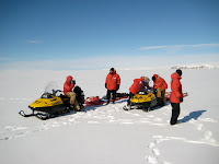
I flew out of McMurdo on November 12 in an Huey helicopter. I arrived at the helicopter pad two hours early, even though I only needed to be there half an hour early for my safety briefing. I flew out with Ken, another ARISE participant, and Thai, the mountaineer for the final leg of the field season in Granite Harbor. We were flying to the north around 100 miles to a location on the Ross Sea, adjacent to the Mackay Glacier which flows out of the Central Transantarctic Mountains. The field party had already been at work for 3 weeks – and I was flying in for the final push. As we flew out, Thai sat near the window and surveyed the ice beneath us. Our camp was set up on sea ice, and the traverse back to McMurdo was going to involve driving 100 miles across sea ice which, at this time of year, is starting to show significant cracks.

From the window of the helicopter I marveled at the icebergs which had calved off from glaciers and became frozen into the sea ice when it froze for the year last year. It was like watching time stand still before my very eyes. Some of the icebergs stand 200 feet tall or taller (and considerably deeper than that below the water surface) – and they reflect light in the most amazing ways, with every shade of white and blue and gray. They stand like sentinels with ever-changing light.

As we flew, we left the volcanic province that surrounds the McMurdo area, and flew past the Dry Valleys and along the Central Transantarctic Mountains. By the time we started to land, we were in an area with high granite cliffs surrounded by expansive glaciers coming right down to the vast frozen Ross Sea. Many of the mountains were covered with ice, but mountain peaks could be seen deep into distance.

As we approached camp we could see flashes of blue and yellow on the frozen seascape below. Towering pinkish granite cliffs came right down to the ice. We gently landed right next to camp, and, when given the signal, I took off my helmet and climbed out of the helicopter. I had arrived!

My friends, who had gone out three weeks earlier, welcomed me warmly and showed me around camp. I was struck by how cozy and warm camp was – out in the middle of the Antarctic wilderness. There were 2 Rac tents, one for cooking/eating/socializing, and one for computing/data processing/ storing and drying out field gear. Scott tents were used for sleeping, 2 per tent, with one bathroom tent.

I couldn’t get over the views from camp. For the first hour, I couldn’t bring myself to go “inside.” Rather, I just walked around and around thinking, “I must be the luckiest person in the world!” Then, when Joan, our cook, made a beautiful dinner of beef in a coconut curry sauce, I knew that I had indeed found Nirvana!

A typical day was to wake up between 6:30 and 7:00 am, and eat a hearty breakfast of pancakes and bacon, or eggs and potatoes, and coffee. By 8:00 we were on our way to the field. (See my previous blog to learn about the purpose for the survey and the way it was conducted). Before the seismic surveys were done, a line had to be flagged. For the first couple of days I was involved with flagging the lines. This entailed using a GPS unit to establish a location. A 50 meter cable was then used to plant a flag every 50 meters, keeping a perfectly straight line with the previous flags. When the flag location was determined, an auger was used to drill a hole in the ice to securely plant the flag. The lines were typically 1 or 2 kilometers long. Once the line was established, we had to go back and label all of the flags, and get an accurate GPS location for each flag, as these would soon be linked to the geophysical data being collected.

The driller and the science lab, both pulled by Piston Bullys, followed later. They would pull their equipment up to each flag and drill, and then collect seismic data. I worked both with the driller, shoveling snow away from the drill hole, and with the science lab, deploying the airgun into the hole. At the appropriate moments, the seismologists would fire the airgun, and their computers would monitor the return of the sound waves from the sea floor and below to the geophones which were in a streamer behind the mobile science lab.

My first day in the field, we were concentrating on flagging a line, when suddenly we saw three emperor penguins walk up to us! They are so playful and curious – and walked right up to us, with absolutely no fear. They stood near us for at least 15 minutes while they interacted with one another, squawking and rubbing beaks, and finally the scooted off. Little did they know they had absolutely made my day!

One day, after our work was done, we went exploring a nearby point called Cape Archer.
To get to Cape Archer we drove our snowmobiles past some deep pressure ridges with seals all around. Here we were able to get up fairly close to see the mother seals and their young pups. The mothers noticed when we approached, but were not afraid. Nearby, there was a seal hole where a mother and her pup kept bobbing up and down in and out of the water. I felt so privileged to have this close encounter with Weddell Seals – and for them to not be frightened of me! I knew I was a visitor in their territory and I felt humbled by their acceptance of me.

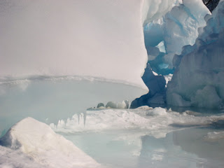
A bit beyond, we came across a magnificent ice cave at the edge of the interface between a granite cliff and a glacier. The colors, texture, and lighting were beautiful as we treaded into the cave – through an old crevasse which used to be deep in the heart of the glacier before it advanced its way toward the sea.
One was always aware that bit could break off or shift at any time – so we didn’t venture too far in, but it was spectacular nonetheless.

After just 9 days in the field, our work was done and it was time to head back to McMurdo with all of our gear. We were going to traverse back from Granite Harbor to McMurdo. The traverse was one of those profound events in life that are
difficult at the time, but that you wouldn't miss for anything. I rode on the back of a snowmobile for 13 hours. The traverse party consisted of 2 snowmobiles, each with 2 persons, and two Pisten Bullys pulling laden-down sleds full of gear, and a total of 6 passengers.
We left sunny Granite Harbor, and in less than a half hour, we were in overcast skies and moderate visibility. The ride on the snowmobile was cold and windy, but a great adventure.
We rode past icebergs, nursing seals, big cracks in the sea ice. We plodded along slowly, with the Pisten Bullys being our limiting factor (maximum speed of perhaps 15 mph). But slowly the mountains and glaciers moved behind us, and Mount
Erebus come closer into view. The snowmobiles stopped at the ANDRILL drill site for a brief bit of warmth and a tour, while the Pisten Bullys went on ahead. 45 minutes later, we took off from the drillsite and sped on to catch up with the advance party of Pisten Bullys. Partway there, 3 Adelie penguins came waddling across our path. With due humility, we silenced the engines and squatted low for them to come and check us out. They appear to be such happy creatures! Again, there were fearless and inquisitive!

When they were done checking us out, and slid off on their bellies, we ignited our engines and took off for the final stretch – to catch up with the Pisten Bullys and make it home in time for "midrats" (Midnight Rations – the midnight
meal served in McMurdo). A windstorm picked up on our final stretch, and our last leg was though a blizzard. We followed the flags to circumnavigate the ice runway, and finally reached McMurdo just before midnight.

Room keys were awaiting us at the housing office. We charged for the showers – and welcomed the chance to get clean – and then settled in for a hot meal and some much needed sleep.

I would have happily stayed out for another two weeks – but I am thrilled to have had the opportunity to get out into the deep field.

Meanwhile, back in the ANDRILL lab, we hit our target depth of 1,000 meters and the windows into climates past are continuing to captivate the science teams. After a brief pause to do some logging of the drill hole, we will continue drilling for another few days before calling it done. The ice is started to soften a bit, and they will need to haul the whole rig (90 tons of it!) soon. What a sight that will be!!